🔄 Updated 21 Jun 2026
Say Roi Et and most people think of the Ho Wot tower and temples first. But the other half of this province's charm is the wide-open fields and big lakes scattered all around. In the town centre, Bueng Phlan Chai is right there for an easy stroll, no long drive needed. Head east to Selaphum and you hit Bueng Kluea, a massive lake with a white-sand beach. Down south around Kaset Wisai and Suwannaphum is Thung Kula Ronghai, jasmine rice fields so wide you can't see where they end. We've grouped everything so you can pick what fits your time and route.
Bueng Kluea — the Isan sea with a white-sand beach
If you had to pick one nature spot in Roi Et, a lot of people would name Bueng Kluea. It's a large freshwater lake of around 7,500 rai in Bueng Kluea sub-district, Selaphum district. The reason locals call it the Isan sea is that one side of the lake is a wide white-sand beach running nearly a kilometre, and looking out you see a sheet of water so broad it really does feel like the coast — just freshwater and no waves. This was a hugely popular Songkran spot for Isan folk back in the '90s, and it's still where locals come to relax today.
- The lakeside beach — wide white sand where you can sit and wade in the shallows. It gets busy over Songkran and long weekends, with a lively mini-beach feel.
- Floating rafts and waterside restaurants — there are raft restaurants serving Isan food and made-to-order dishes where you can sit, eat and take in the view. Order grilled fish, som tam and grilled chicken and enjoy the breeze off the lake.
- Water activities — you can rent rubber rings, swim and paddle boats. On weekends there are sometimes water bikes or extra seasonal activities.
- Birdwatching — Bueng Kluea is a waterfowl conservation area, and from late in the year into early the next, water birds come to roost, so bird photographers can spot them here.
Getting there from Roi Et town, you take Highway 23 through Thawat Buri to Selaphum, then turn onto Highway 2259 and follow the lane down to the lake, roughly 35–40 km from town and about 40–50 minutes' drive. It's open during the day, around 05:00–18:00, with free entry. Your costs are basically the food on the rafts and renting water gear.
When to go
Bueng Kluea is most fun in late rainy season into early winter, when the water is full and the air is cool, and around Songkran when crowds come out to play in the water. In the peak dry season the water level can drop and the beach looks drier than usual. Go on a weekday and you'll get a much quieter atmosphere than on weekends.
Want more out of Roi Et? Book tours & activities
Booking online ahead on Klook or GetYourGuide is usually cheaper than the gate and skips the queue. Pick only the experiences you actually want — prices and availability are shown live on each site.
Thung Kula Ronghai — jasmine rice fields to the horizon
Thung Kula Ronghai is a vast flat plain spanning five Isan provinces — Roi Et, Maha Sarakham, Yasothon, Surin and Si Sa Ket. The Roi Et portion lies around the districts of Kaset Wisai, Suwannaphum, Pathum Rat, Phon Sai and Nong Hi. The name Thung Kula Ronghai (literally "the plain that makes the Kula weep") comes from a legend of travelling Kula merchants who hawked their goods across this huge plain until they were worn out — no matter how far they walked, they never seemed to clear it. What makes the place special is that it's the source of Thung Kula Ronghai jasmine rice — Khao Dok Mali 105, GI-registered for its fragrance and quality.
For visitors, the charm of Thung Kula is the view of rice fields running flat all the way to the horizon. Drive the road through the middle of the plain and you get an open feel you just don't find in the city. The spot people like to stop at is around Dong Khrang Noi sub-district, Kaset Wisai district, where a road cuts through the fields and there's a Thung Kula sign for photos.
- Rainy season (Jun–Sep) — the fields are a fresh green of young rice, with standing water reflecting the sky, great for green-view shots, though the roads through the fields can get muddy at times.
- Late rainy into early winter (Oct–Nov) — the rice starts to head out and the fields turn green-gold, the air starts to cool, and it's the easiest time for driving around.
- Harvest season (Nov–Dec) — the prettiest stretch, the whole plain turning a glowing gold of ripe rice, with a faint scent of jasmine rice drifting on the breeze.
Tips for shooting the fields
The best light is early morning and late afternoon before sunset, when the fields catch soft light and a clear golden tone. Drive slowly, find a safe place to pull over by the road, then get out to shoot. Respect the farmers' paddies — don't walk into the rice plots — and keep in mind that outside the growing season the fields are bare and brown, neither green nor gold.
Bueng Phlan Chai — a lakeside park in town, open every day
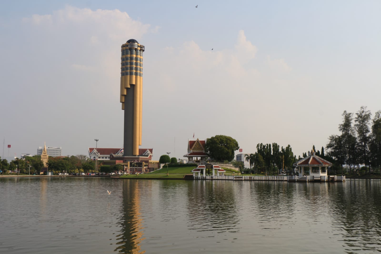
If you'd rather not drive far, Bueng Phlan Chai is nature right in the middle of town. It's part of Princess Mother Srinagarindra Park in Roi Et, covering around 120 rai. The highlight is a large lake with an island in the centre, linked by bridges. On the central island there's the city pillar shrine, a Buddha image and a monument to Roi Et's first city ruler. The shore is shaded by big trees, with walking and running paths, exercise areas and quiet spots to sit by the water.
Lake bridge & Ho Wot photo spot
There's a bridge and a pavilion out over the water you can walk to for photos. From here you can frame both the expanse of Bueng Phlan Chai and the Ho Wot tower nearby — a check-in spot visitors to Roi Et love to grab.
Pedal boats & duck boats
You can rent pedal boats to potter around the lake. There are lots of fish in the water, and you can buy fish food for the kids — a relaxed outing for the whole family with no need to rush.
Morning & evening exercise
Around the lake there are walking and running tracks and a cycle path. Locals come out to exercise in good numbers morning and evening, and some days there's a musical fountain to watch — a go-to relaxation spot for townsfolk.
Bueng Phlan Chai is in town, open from around 07:00 in the morning until about 20:00 at night, with free entry. It's right next to the Ho Wot tower, an easy walk between the two, so if you only have half a day in town you can pair these two perfectly.
Other lakes and nature worth a stop
Beyond the three main spots, Roi Et has more lakes and nature scattered across the districts that fit nicely along one route, especially around Nong Phok, a forested upland area with waterfalls and reservoirs for a change of scene from the rice fields.
- Pha Nam Yoi (Nong Phok district) — a natural cliff within the grounds of Wat Pha Nam Thip, where water seeps and drips from the overhang year-round, which is where the name comes from. It's a wide forest-and-hill viewpoint you can pair with Phra Maha Chedi Chai Mongkhon.
- Tham Soda Waterfall (Nong Phok district) — a waterfall in the Pha Nam Thip non-hunting area, near Ban Non Sombun, Phukhao Thong sub-district, close to Huai Phung Yai Reservoir. It runs well in late rainy season and suits people who like forest-and-hill nature.
- Huai Phung Yai Reservoir (Nong Phok district) — a reservoir set among the forested hills, with quiet views of water and mountains, a good stop for photos on the way up to the chedi.
- Ku Ka Sing (Kaset Wisai district) — not a lake, but a Khmer-era historical site in the middle of the plain. It's an easy add-on along the Thung Kula Ronghai route, good for those who like history alongside field views.
What to know honestly
Roi Et's nature is more about fields and lakes than waterfalls or mountains. If you come expecting forested, lush-green-all-year check-in spots, this may not be the place. But if you like wide views, the breeze across the fields, big stretches of water and a quiet, truly Isan atmosphere, Roi Et delivers — and most of it is free or costs very little.
A 2-day Roi Et nature trip
Roi Et's lakes and paddies sit in different directions — Thung Kula is to the south, Bueng Kluea to the east, and Pha Nam Yoi to the north at Nong Phok. Looping all of it in a single day is tiring and eats up a lot of road time, so we've split it into two days: day one covers the town and the north, day two heads south to Thung Kula then stops at Bueng Kluea before heading back. If you only have one day, just pick the route you like.
In town + north to Nong Phok
Heading south — Thung Kula Ronghai + Bueng Kluea
Getting around
Almost all of Roi Et's nature sits in outer districts with little public transport, so having your own car or a rental is by far the most flexible option. Fill up before you head out of town, as petrol stations can be far apart on some stretches. If you fly into Roi Et airport and rent a car from there, you'll be able to cover the lakes and paddies most completely.
Plan a full Roi Et nature trip — lakes, fields and where to stay
See the Roi Et travel guide →